| WEATHER STORY Bismarck Weather Forecast Office |
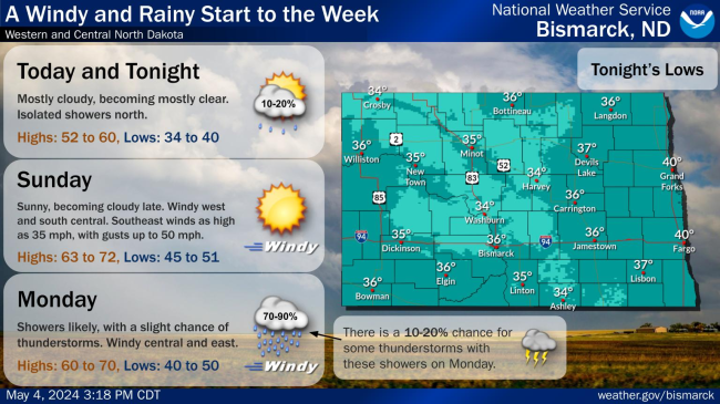
|
|||
![]() |
|||
|
⚠️ SEVERE WEATHER TIMING (JUNE 9TH) ⚠️
A severe thunderstorm are forecast to track from west to east and is expected to bring significant impacts across North Dakota this afternoon and evening. Please stay weather-aware and have multiple ways to receive warnings!
⏱️ Expected Timing:
3 PM – 6 PM CDT: Western ND (Williston, Dickinson, Bowman, Crosby)
5 PM – 9 PM CDT: Central ND (Minot, Bismarck, Washburn, Elgin)
7 PM – 11 PM CDT: James River Valley / Central-East ND (Harvey, Carrington, Jamestown, Ashley)
8 PM – Midnight CDT: Eastern ND (Devils Lake, Grand Forks, Fargo, Langdon)
Potential Impacts:
Hail: Up to the size of tennis balls
Winds: Damaging gusts as high as 80 mph
Tornadoes: A few tornadoes are possible, one or two of which could be strong
Action Item: Charge your devices, review your severe weather safety plan, and make sure your wireless emergency alerts are turned ON.
|
Select a Different Office Below
Data Courtesy of Bismarck Weather Forecast Office

